The briefing that knows what matters right now.
Two modes. Standard delivers the complete traditional FAA briefing structure — every product, always available. Smart Briefing reorganizes everything into seven pilot questions, adapts content to your time-to-departure, and leads with a GO / MARGINAL / NO-GO banner computed from all available data.
"Can I get out? Can I get in? Is my backup good?"
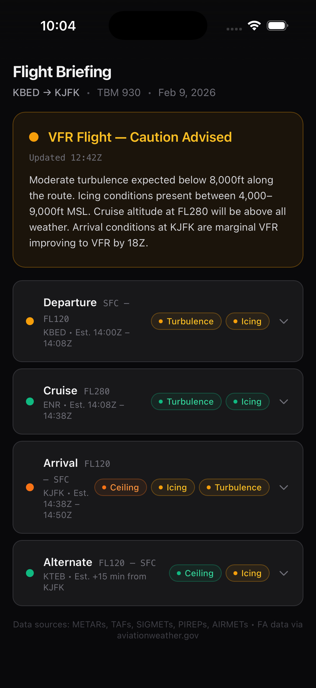
Smart Briefing replaces the source-by-source format with seven pilot questions. Departure pulls together METARs, TAFs, crosswind analysis, runway closures, and SID NOTAMs — and tells you whether you can get out. Arrival asks whether you can get in: destination METAR and TAF, approach availability, runway status, services. Clouds, Ceilings & Icing covers route flight categories, icing advisories and PIREPs, freezing level, and GFA. Wind & Turbulence gives you winds at filed altitude, headwind/tailwind comparison, and turbulence advisories. Thunderstorms pulls radar, convective SIGMETs, and the convective outlook. Airspace flags active TFRs, SUA activations, and ARTCC NOTAMs. Each bucket shows a severity badge and a one-sentence verdict. Tap to expand the raw products behind it.
- Departure: METARs/TAFs, crosswind analysis, runway closures, SID/ODP NOTAMs
- Clouds, Ceilings & Icing: route flight categories, icing advisories and PIREPs, freezing level, GFA
- Wind & Turbulence: winds at filed altitude, headwind/tailwind, turbulence advisories and PIREPs, LLWS
- Thunderstorms: radar, convective SIGMETs, convective outlook, storm PIREPs
- Airspace: TFRs with polygons, SUA activations, airspace and ARTCC NOTAMs
- Arrival: destination METAR/TAF, crosswind, approach availability, runway closures
- Alternate: weather and approach availability at your filed alternate
The right products at the right time.
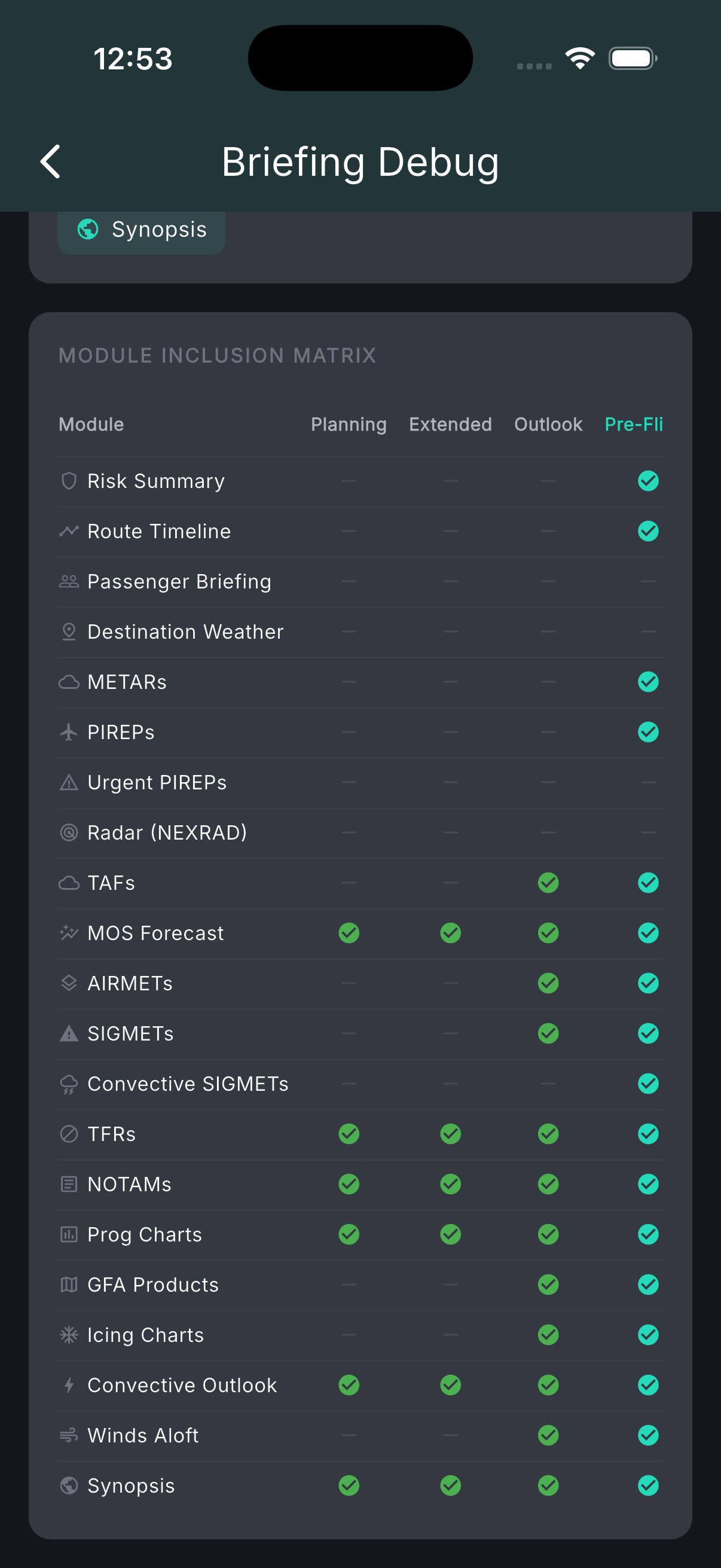
Smart Briefing automatically selects what to show based on time-to-departure. More than 48 hours out, you need long-range feasibility — prog charts, the SPC convective outlook, NOTAMs, and TFRs. The night before, it narrows to TAFs, 12–18 hour GFA panels, icing forecasts, and AIRMETs. Morning of departure, it leads with current METARs, the risk summary, route timeline, and PIREPs from pilots who flew this morning. Two hours out, it's radar, the latest reports, and the final call. Once past your ETD, destination weather moves to position one and the route timeline shows only remaining hazards.
- Planning (>48 hrs): prog charts, convective outlook Day 3, NOTAMs, TFRs
- Extended (24–48 hrs): prog charts (48h), convective outlook Day 2 with probabilities, MOS
- Outlook (12–24 hrs): TAFs, GFA 12–18h, icing FIP, winds aloft, AIRMETs/SIGMETs
- Pre-Flight (2–12 hrs): METARs, risk summary, route timeline, PIREPs, icing CIP + FIP
- Departure (0–2 hrs): NEXRAD radar, latest METARs, urgent PIREPs
- Enroute: destination weather at #1; route timeline shows remaining hazards only
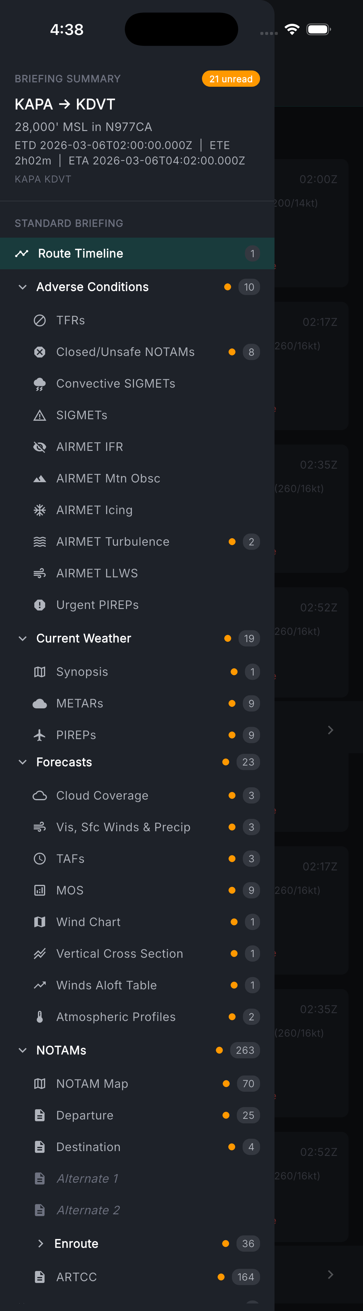
Standard briefing — every product, every time.
If you want the traditional structure, Standard delivers it in full. An interactive route timeline sits at the top — waypoints, ETAs, distances, altitudes, nearest weather stations, winds, and hazards across the entire route. Then adverse conditions: TFRs, closed or unsafe NOTAMs, convective SIGMETs, SIGMETs, all five AIRMET types, urgent PIREPs. Current weather: surface analysis synopsis, METARs with flight category, temp, dewpoint, wind, visibility, ceiling, altimeter, and density altitude, plus PIREPs. Forecasts: TAFs with change groups, GFA cloud and surface panels, MOS, a wind chart, vertical cross-section at cruise altitude, winds aloft table at eight points along the route, and HRRR soundings at departure, enroute, and destination with Skew-T data, stability indices, icing bands, and freezing levels. NOTAMs categorized by station — departure, destination, alternates, and enroute — plus ARTCC NOTAMs for every center the route crosses.
- Route timeline: waypoints, ETAs, altitudes, nearest stations, winds, hazards
- Adverse conditions: TFRs, critical NOTAMs, convective SIGMETs, SIGMETs, AIRMETs (IFR, icing, turbulence, mountain obscuration, LLWS), urgent PIREPs
- Current weather: surface synopsis, METARs (category, temp, dewpoint, wind, visibility, ceiling, density alt), PIREPs
- Forecasts: TAFs, GFA, MOS, wind chart, vertical cross-section, winds aloft table, HRRR soundings with stability indices
- NOTAMs: departure, destination, alternates, enroute by category, ARTCC NOTAMs